Out the back of the country lands between Cambridge and Matamata, lies Maungakawa Summit. Warrens selling point for today was to tell us (and just quietly i think he had himself fooled too) that the hill was not much bigger or harder than Kakepuku which we can see from home and that walk is certainly easily achievable to scale. In all fairness and to keep things in check the reality was that we all needed some exercise and the kids needed to get out and run around in fresh air and the added bonus of another SOTA summit ticked off for Warren and into the log was of course a featured incentive .
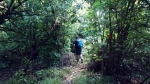


About 3/4 of the way to the top we met two elderly ladies, fit and looking good. They stopped for a chat about the rest of the track thinking as we had the kids with us that we had seen the walk advertised as a great family walk to fill in an afternoon. They told us that they had not made it to the top and had turned back as the track was quite steep and hands and knees material. Well we have all been up the Kawekas together in Hawkes Bay and Warren and I have been to the very top of Pirongia a couple of years ago before SOTA was even in the making for ZL and so we weren’t about to give up without good reasons. We were pleased to find that while the track was not well marked out, certainly steep in places, slippery due to recent rain falls and overgrown tracks covered in mangled messes of tree roots the top was within our capabilities. You certainly do need good walking shoes if you are going to tick off this walk / summit.


The views at the top stretched far and wide, although limited by the summits plant life.
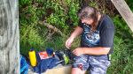
Once up at the summit Warren discovered the coax was left behind after our last adentures to Altimarloch, so a quick modification was made and the dipole was broken in half with one leg fed direct into the antenna port feeding a 10 meter long wire. Fortunately the platform provided a good support for getting the wire mostly vertical. Once on the air a quick contact with ZL3CC who was on a summit in Christchurch was made and added to the log. A few more on 7 MHz, 14 MHz and 3 contacts on 146 MHz FM using the FT 60 handheld from the top of the platform. A total of 14 contacts in the log before we decided we needed to close shop and get down the hill before risking darkness.
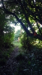
The trek out of the bush was definitely one that reminded us of the basics of going into the bush and being prepared as well as staying together as a team. We decided to take the loop track down again. Although longer time wise it was meant to be the easier of the ways to the top / down again. that are available. I guess on the day you could say that it really depends how you interpret that because the track is certainly a challenge in its own rights. A number of the reflector markers were missing or on the ground and may not be seen if they became covered in some way. The track is certainly not clear and we made a few slight wrong turns but quickly realised we were going the wrong way. There was definitely no running off ahead for the kids today, their little hand radio’s with them or not. The track had some pretty muddy, wet slopes to navigate and then there was the fact that we had picked an afternoon to the this walk and so the decent was on the dark side of the mountain in the bush all the way back to base.
We were pushing to get out of the bush away from potential wrong turns before the last of the light faded. We made it out but id say another twenty minutes and we would have been in complete darkness with no torches on us (though i think about it now and i suspect there is a small one in Warrens pack along with first aid supplies). With this in mind it is a good time for us all to think about personal safety when out and about like this and to go prepared for all possibilities.
Details
Summit ZL1/WK-134 Maungakawa
Height 495 mASL
Access – Doc parking area on Piakonui Road. Walk to summit
Nominal time to summit – 1.5 hours walk up. 2 hours down via loop track (anticlockwise).
Summit Marker – Platform.
Land Access Permission – DoC – not required.

![]()