On the southern end of the Kaweka Ranges is a summit called Don Juan. We decided this would be a good summit to activate during our weekend in Hawkes Bay. The drive out to this one takes a little while but the walk is fairly moderate with a 250 m ascent. A good bit of huff and puff for a Saturday afternoon with some radio and views.


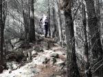
The track started out with a push up, but it wasn’t to severe. It leveled out however there were plenty of wild pines that had blown across the track to navigate. A final steep climb up to the trig and we were there. The trig is slightly off the track but easily visible. In any case the track passes through the activation zone. Unfortunately the views were a bit limited to gaps in the fauna but what we could see was great. The wind wasnt to friendly today however so we hunkered down for lunch and SOTA.


A VHF contact to Ray ZL2RB kicked off the session. 40 metres was a no go, although I heard a couple of stations calling this band was not in the mood to play radio. I switched down to 80 and made easy contacts around ZL. 20 was open to VK so a few more contacts were added to the log. A total of 9 contacts made for a happy activator. I was surprised 80 worked as well as it did. There wasnt really enough real estate to fully stretch out the 80 metre section of the dipole so it had a few kinks in it, and was merely 2 metres above the ground. Amazing what you can do just by having the right bands available.
Take care crossing the 2 fords on Locktow road. Emma’s front wheel drive Honda made it ok but it did make her a little nervous. My 4wd Land Rover is in the shop unfortunately.


Details
Summit – ZL1/HB-061 – Don Juan
Height –943 m
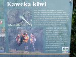
Access – Follow Puketitiri Rd past Puketitiri, turn left into Whittle then left into Locktow Rd (just after the quarry). Park up at the end of the road (take care through the 2 ford crossings). Follow track markers to Don Juan summit (turn left near start of track as per sign then carry on to the top).
Nominal time to summit – 45 minute drive from Hastings. About a 1.5 hour walk to the summit.
Mobile and internet coverage from the summit – Limited coverage – if you stand in the right place you can get spots out.
Repeater coverage – 670, 725 access from summit only.
Summit Marker – Trig
Land Access Permission – Not required – DoC Land.

![]()