For our next summit we decided a trip up to Coromandel was in order. The plan was to knock out a couple of 2 pointers with a swim in between but as you will see that didnt eventuate. The drive up to Coromandel takes a bit – being roughly 3 hours from home. A good chance for the kids to get a nap. Kaipawa trig can be accessed from the North and South. Recently Dave VK2NU activated the summit from the South track so we thought we would try from the North. At the top of Kennedy bay road there are access ways to the north and south. We took the south access which required 4 wheel drive and found the start of the track. This was a useful headstart to the summit.
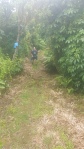

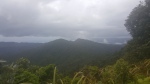
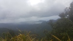
The track is a lot of ups and downs, some quite steep in places, but nothing requiring chains or stairs. Across the tops are fantastic views to the east and west of the peninsula and into Coromandel.


Once at the top I worked ZL1AAF Ross on 146 MHz who I had been talking to on the drive up. Then once set up on HF I worked Jackie and John on 40 who were activating Klondyke. A nice S2S. With no other takers on 40 we switched to 20 and added another 2 VKs and 2 ZLs to the log. A total of 7 contacts. Just as I was attempting to arrange another contact the heavens opened up and rain set in. A very quick pack up and we were off.
With full on rain the track was a bit slippery in places on the way out and we were thoroughly soaked. Once we got back to the car it eased off but any thoughts of the beach or another summit had passed in lieu of an icecream and home.


Details
Summit – ZL1/WK-113 – Kaipawa
Height –586 m (height gain of roughly 100m)
Access – From the top of Kennedy Bay Rd, there is an access way on either side of the road. If you have a decent 4 wheel drive vehicle turn to the south track and follow the track to a signed park just below the radio tower. For other vehicles use the north track and park up. Walk the 4wd track.
Nominal time to summit – About 2.5 hours drive from Hamilton. 1 – 1.5 hour walk to summit.
Mobile and internet coverage from the summit – Excellent coverage.
Repeater coverage – 6975 is easily accessible from the summit.
Summit Marker – Trig.
Land Access Permission – Not required – DoC Land.

![]()