We had a bit of choosing to do before we selected this summit to activate. Other contenders were ZL1/WK-200 which we discovered was on private land, ZL1/WK-141, which we found was a 5 hour walk without permission, and ZL1/WK-054 which was probably a bit to big for us to manage today. So with a bit of advice from John ZL1BYZ we selected this summit ZL1/AK-018. While it is unnamed on the map it is right above the town of Clevedon, South East Auckland. It also is part of Te Araroa, or so we thought.


At the end of Thorps Quarry Road in Clevedon is a scout hall with a car park and amenities. Follow the main track from there over the swing bridge (or through the ford if you prefer) and head up from there. Turn right at both the track junctions and follow your way to the look out platform. However be aware – this is not the summit. If you look East you will see 2 higher hills. The left hand one is the true summit. Once you have taken the prescribed amount of photographs and sight seeing in, head back the way you came for about one minute and you will see an orange triangle pointing left at about eye level. This is the track to the true summit. This track is not well kept and could do with some gardening, however if you follow the orange triangles you will go over the first lump to get to the second lump where the trig is located. The trig is slightly off the track but the track passes through the activation zone.
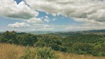


We made it to the top and worked John and Jackie on VHF before settling in to lunch then getting set up for HF. The contact with John completed the summit for both of us. On HF the bands were a little difficult. We started on 14 MHz and worked Gerard and Rick from Australia and then Phil from Auckland (ground wave?). Then we QSYd to 7 MHz and added John ZL1DT, Geoff ZL3QR and Kyle ZL2KGF in the log. While I was working ZL2KGF I noticed my power meter on the KX3 was not as enthusiastic as it usually is. A check revealed I was only running 3 Watts. I pushed it back up to 10 Watts and while Kyle said I improved it did not add any more contacts to the log. So we packed up and headed back down to an ice cream and fresh up from the Clevedon dairy.

This one is a relatively easy one to do if you are aware of the track that spurs off near the lookout. If you take a slasher with you and prune the gorse I think we all would be thankful.
Details
Summit – ZL1/AK-018
Height –257 m (You pretty much climb all of this)
Access – From scout hall carpark, end of Thorps Quarry Road, Clevedon. See text for directions.
Nominal time to summit – About a 90 minute walk
Mobile and internet coverage from the summit – 4G on Voda.
Repeater coverage – 6625 easy copy from summit.
Summit Marker – Trig.
Land Access Permission – Clevedon reserve – not required however there are houses up there and you cross into their land so be respectful.

![]()