After another weekend in Hawkes Bay, this time for the annual Bay MC, One Night Stand Motorbike Rally with Warren and a couple of his friends working the sound station for the event, we had plans for an attempt to tick off a summit on our way homeward bound on Sunday afternoon. At first it seemed that the powers that be were not going to be on our side. Weather, and access issues being the main things standing in our path. Heading home however along SH1 between Taupo and Tokoroa among the forestry we found a summit to conquer.

Warren is well prepared for SOTA, i suspect its on his mind 24/7 and likely in his dreams as well, and on his laptop he has a map with all the summits, so traveling along the road we had to pull over a few times to find possible summits to tackle before we reached home – TeKawa, Te Awamutu – Waipa District. After finding the turn off on SH1 we traveled down a road a short way, through huge pot holes filled with water and discovered the correct entry to the forestry and the summit hill. The gates were open and with no signs indicating a closure time or the tracks being in use we made our way up the track. A couple of wrong turns and we made it to the summit, towing a trailer right to the summit. Thankfully the summit road / track was in good order all the way.


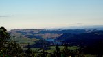

The top of the summit is home to a cell site, a loop track and not a lot else other than shrubs and other plant life. The views are largely closed off by the Natural surroundings, though you can get some clearish views in parts, short of climbing up onto the fence at the very top of the summit. A great view of the Waikato river leading into Atiamuri was noteworthy (picture 3 above).

Warren made short work of getting his ling strung from the top of the summit to a tree across the loops drive way track, before going live on the air. Warren made 11 contacts to ZL and VK using 20 and 40 meters. The cell site generated plenty of QRM on 40 meters so operating frequencies were chosen to minimise the impact of the noise.


This was just a short trip and activation in the log and we were soon packed up and back on the road, homeward bound.


Summit Information
ZL1/WK-102 Ngautuku
Summit height – 629 m
Access via forestry road near the bull ring hotel. SH1 between Taupo and Tokoroa
Nominal time to summit – 15 minute drive – 4wd required.
Summit marker – Cell Site.
Land access permission – Unsure, is situated on Maori land.

![]()