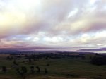

This morning we set off from home at the unsavory hour of 5.15am. That meant an even more unsavory wake up of 4.30am, in order to reach Tauhara at not long after 7am. The day was perfect for tramping – overcast and warm but cool at the same time. The worst part of the tramp was in fact the beginning, the part that goes across hilly farm land to the base of the mountain track upwards to the summit, although it did give some awesome views down into Taupo township.


Once at the base of the mountain the track to the summit is all in bush land up and through a winding path with a gentle climb all the way to the summit. The the track is well used and we saw many people out and about enjoying the tracking including two local elderly ladies who were clearly very fit as they raced off ahead of us. We are much slower and just took our time. The track is not marked in any sort of fashion although its easy to find your way as the track is visible in the ground, though in a couple of places the track goes in two direction – don’t be fooled though, they do link up again after a very short distance and some of them you can see both tracks at the same time.


About 3/4 of the way up we hit the overhead cloud and that remained with us for the remainder of our tramp to the top. The cloud stuck around for a good half an hour once we reached the summit, before it cleared revealing spectacular views down into Taupo and the surrounding land behind it. From the summit there is a walk way along the ridge to an exposed rock which was being enjoyed by many to get a unique view of the area, one you would never be privy to from the ground
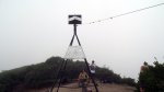


Initial contacts were made on 2m simplex, with some locals. A 40m contact to John ZL1PO was made before attempts were made to hail VK. Warren took a punt and tried 18 MHz, however he needed to engage the receive attenuator as he was getting interference from a local radio station, odd as there is no commercial radio equipment up this summit. 18 MHz chose to be ideal and Warren managed to work a collection of VK chasers before we packed up and headed down.


This summit has only recently been opened back up to the public. It was closed a year ago due to vandalism. If you do decide to ascend this summit, please, as with any summit, keep in mind we are at the behest of the good will of the landowners.

Summit Information
ZL1/WK-026 Tauhara
Summit height – 1088 m
Access via car park at end of Mountain Road. Track starts across farmland – follow the markers. Past the water tanks and follow the track to the summit.
Nominal time to summit – 2 – 2.5hr walk.
Summit marker – Trig Station.
Land access permission – The owners have granted public access to the mountain, but check the sign board at the car park first to be sure. Please read the conditions of entry on the sign board.

![]()