A quick activation here as I was running out of light. The road to this summit is extremely long and windy. If you take passengers they may get motion sickness. I think I may have even given myself a headache with driving the road between Pirauau and this summit. On the grey line is great for DX but in mid winter it is also very cold – especially at altitude.
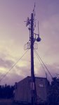


This summit hosts a comms unit for the local power authority and is roadside so no permission is required to activate it. Sadly the view is closed in except for a narrow view to the East to Tolaga Bay.
With the help of the grey line I made 18 contacts from this summit all on 7 MHz, in about 15 minutes. By then it was almost completely dark and very cold so it was time for a quick pack up and head back to town to see if I could stomach any food, and an early nights sleep before teaching the next morning.
Details
Summit – ZL1/GI-089 Arakihi South
Height –638 m
Access – From Gisborne, Back Ormond Road, Waimata Valley Road, Hokora Road. Due to the long windy road a GPS with map would be very useful!
Nominal time to summit – 90 minute drive from Gisborne – windy road.
Mobile and internet coverage from the summit – 3G on Vodafone patchy – stand in the right spot.
Repeater coverage – 685 access.
Summit Marker – Trig and radio site.
Land Access Permission – Not required – roadside.

![]()