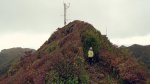
For our next challenge we decided we would give Karioi a go. Karioi is an extinct volcano just south of Raglan. It has been on our to do list for a while so on Sunday we set out. The weather was a bit cooler than we usually climb in but it made for a comfortable walk up.

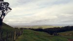
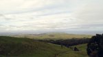

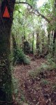
The track through the farmland starts out gentle until you reach the final paddock where it is a push up to the bush line. From there it is a gentle incline through the bush until you near the summit where it gets gradually steeper until you encounter ladders for the final ascent. Typical volcano. The track was well marked and we had no problem letting the kids go off ahead of us sloweys. We carry portable radios to keep in touch just incase.

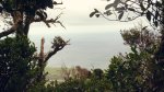


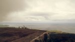
Once at the top we were just under the cloudline but could see Aotea and Kawhia Harbour to the South, and Raglan harbour to the North. The wind was a bit cool on the summit so we found shelter and got set up while eating lunch. Myah hunkered down in a hole in the rock. I managed to work John ZL1BYZ and Jackie ZL1WA on VHF simplex from the handheld and he offered to spot me as the mobile coverage was hit and miss. On 40 I worked Geoff and Bev ZL3QR and ZL3OV who also wanted the grid square for another award. ZL3NB Bill also showed up from Christchurch just before I moved up to 20. There I had a good collection of VKs reply to my calls and had a good collection in the log before we packed up and started our way back.


Wyatt was keen on power walking down the hill so I tried to keep pace with him as Myah and Emma took a slower pace down. Once back at the car we took a backroad to Raglan and dined on fish and chips from Kopua domain.


Details
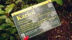
Summit – ZL1/WK-063 – Mount Karioi
Height –756 m
Access – Follow Highway 23 towards Raglan. Turn left into Te Mata Road (signs for Bridal Veil Falls), right into Ruapuke Rd then right into Karioi Road. Park up by the signs then follow the orange triagles through the farm then through the bush to the top.
Nominal time to summit – 30 minute drive from Hamilton. ABout a 2-3 hour walk to the summit.
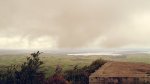
Mobile and internet coverage from the summit – Limited coverage – if you stand in the right place you can get spots out.
Repeater coverage – 6625, 7375 and 5675 access.
Summit Marker – DOC Marker + Radio tower..
Land Access Permission – Not required – DoC Land.

![]()