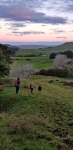
Back in Hawkes Bay chasing hills…..The end of the electrical teaching season left us with a free Saturday afternoon to fill and fill it we did. After a bit of door knocking to gain permission to enter private farm land, it was up another summit we ventured. Mount Cameron Summit is shared by two land owners on either side. We had success with the 2nd of the two, who was more than happy to let us roam his hill sides and make our way to the summit on our own, although he, he was kind enough to offer a quad bike ride to the top as it is pretty wet in places at this time of year. The walk is steep in places, but not unmanageable for anyone with good balance and walking shoes, and the ability to either jump a fence or two, or do as we did and go through the fence wires….ever so gracefully….wink wink. It is about an hourish to the summit and no track, so GPS was helpful though if you know the general direction its not that hard to find. We didn’t go right to the trig, but stopped inside the activation zone as it was getting late in the afternoon, and, so time was limited.
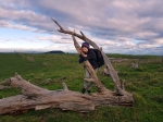
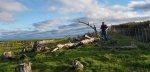

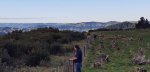
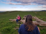
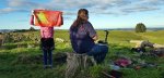
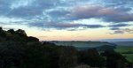
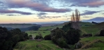
Warren got set up while the kids admired the local wild life “Fluffy Cows” on the other side of the fence and admired the views from all sides of our resting spot. With a reasonably clear winters day and skies, the view was pretty decent on all sides.


The first contact made was with Gerard on Mount Bindo VK2/CT-003 for a summit to summit. While Warren was working on 40 Mike ZL2WR was calling me on VHF. Warren had to clear out the 40 m calls to stand up and move around so that Mike could hear him. Time (daylight hours) was against us so only 8 contacts in the log from this summit. This is a good walk and the farmer is very friendly to deal with.


Details
Summit – ZL1/HB-136 Mount Cameron
Height – 383 m ASL (240 m ascent)
Access – Dartmoor Road – park up in grass area on right apx 500 m down from the station gateway. Walk up the spur on the left between the 2 creeks. Once you run into the bluffs head to the right end of the ridge to get on top, follow the quad track to the paddock. At the top corner of that paddock at the end of the stump line (near old yards and tyres) is well within the AZ. You can get closer to the trig but dont cross any deer fences (as this puts you into the other neighbours property)
Nominal time to summit – 30 minutes drive from Hastings, 1.5 hours walk up.
Mobile and internet coverage from the summit – Vodafone is OK at the summit.
Summit Marker – Trig.
Land Access Permission – Required from Mount Cameron Station (Gus).