Gisborne’s closest and publicly accessible summit is Town Hill. For my annual training trip to Gisborne I thought I would add this one to my list. The weather looked sketchy but I figured I would risk it. Half way up dark clouds gathered on the horizon. However I still favoured pushing on – what is a little rain anyway right? Fortunately the rain left me alone mostly except for a light shower which at the time was quite refreshing.


I opted to do this track anticlockwise which was the way the orange triangle markers were set up. The maps show the track going over spot height 252, but they skirt round to the left following the 200 m contour. Coming down the actual track deviates from that shown on the map – but the track and markers are well established so there is no chance of getting lost. At the end of the walk out there is a small rise to scale which seems unfair when you are so near the end. The track as a whole was good for the legs and one I would do again.
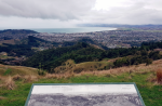
Views from the summit even on this grey day were impressive. You can see Gisborne, and right across Poverty Bay.


The trig made for a useful aerial mast and I set myself up beside the surveyors millennium plaque. In total I made 9 contacts from Town hill including a summit to summit with Soren on Puketutu. Thanks Soren.
Details
Summit – ZL1/GI-155 Town Hill
Height – 290 mASL (height gain of 230 m)
Access – End of Shelley Road. Follow orange triangles. Be aware access is closed for lambing from the 1st August to the day before Labour weekend each year.
Nominal time to summit – Signed at 3 hours return. About 1.5 hours each way.
Mobile and internet coverage from the summit – Vodafone is OK at the summit.
Repeater coverage – 680 690 and 950 good.
Summit Marker – Trig station.
Land Access Permission – Not required – DoC track.