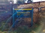
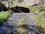
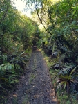
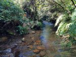
I had a free day to kill so decided I would give Motere a go. While the day was sunny it was still quite cool under the canopy. That said it was still a pleasant day for a walk in the bush. Motere is East of Taumaranui. The track starts accross farmland and then turns into a quad bike track. There are a few stream crossings so be prepared for wet feet.

I didnt venture to find the true summit, settling to be within the activation zone, which the track passes through. You will need your GPS to help make this assessment though. Where I set up was damp and mossy, with no views to speak of. Lets hope the radio had better luck.

9 contacts were made over the space of an hour, all on HF. Band conditions have been challenging. 2 contacts on 5, 3 on 7 and 4 on 14 MHz. I was hoping to catch a summit to summit with Soren from Te Aroha but he had been delayed so it wasnt to be.
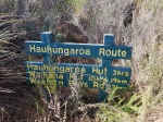
I did try to find the track junction to Tuhua and I rekon it hasnt been used for a very long time, overgrown with blackberry. Some gardening might help and it might be the tale of a future expedition. I also located the remains (a window sash) of the old hut that was located not far from the track.


Details
Summit – ZL1/MW-077 Motere
Height – 991 m ASL (400 m ascent)
Access – From the end of Mangakahu Rd – follow the track through the farm and up the mountain (East).
Nominal time to summit – 2.5 hour walk.
Mobile and internet coverage from the summit – Very patchy.
Summit Marker – Unmarked – GPS to find the activation zone.
Land Access Permission – DoC land – provided you stay on the track.