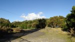
After leaving Taupo the plan was to head home, though as our feet were sore and Taupo township was bedlam due to the iron man competition on that day we headed Rotorua way for some lunch and an intended stop to soak out feet in the foot pools, though another summit was first on Warrens wish list after our lunch. We headed to Ngongotaha and decided to see how far we could get. We managed to make it 3/4 of the way up before being met by a locked gate. Luckily the gate had a walk way through it allowing public access to walk up to the summit, though there was views on the way up in parts – the view at the top was lacking and was just bush around a loops track with some towers at the top. The 1km, 15-20min walk we had been told was ahead of us was far from that and it took a good slow hour to reach the top, i say slow because my feet were throbbing from this mornings hike. We made it to the summit however and Warren managed to activate another summit for his SOTA log.

The path to the summit is sealed, where the road use to run right to the top.You could conceivable pushbike to the summit, and we were passed by a local doing just that. The summit is close to Rotorua so an easy one for locals to activate and get going with.


From this summit we worked a few locals on 40 meters then switched to 20 meters and worked VK. Conditions were a little trying as we were approaching the grey line. Those that we did work – thanks for the contacts.

Summit Information
ZL1/WK-062 Ngongotaha
Summit height – 757 m
Access via carpark at end of Mountain Road. Follow road up to the summit
Nominal time to summit – 45 minute walk.
Summit marker – Trig Post.
Land access permission – not required.

![]()