Rainbow Mountain is homed in the Bay Of Plenty, not far from the geothermal wonderland of Rotorua and from its summit you get a 360 degree view of the surrounding mountains and lakes. We left home today at 5.30am and set off on our hike around 7.30am. The summit track is labeled as an advanced track, although it is not overly difficult there are some step places, especially as you get closer to the summit. It is not a track you would want to do in the rain as it can be slippery in places. Walking time to the summit is approximately 1.5hr of steady non stop walking.


The track is shared with mountain bikers and is maintained by DOC (there is a separate track for mountain bikers to come down once they have reached the summit), although with any mountain it is an expectation that you take your rubbish with you and respect the forest / tracks you have the privileged to access for personal use. Today’s weather conditions were almost perfect for tramping – heavily overcast with light rain forcast for the afternoon. The first part of the walk takes you to a fork in the track with a short 30m walk to the lookout of the crater lake (pic one below, also seen in the cover pic). The walk to this first attraction from the car-park is an easy 15mins.
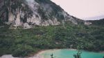


Once we reached the summit the views although heavily clouded in stretched for miles and as we had read earlier the views of the surrounding lakes and mountains were worth the wait.


Warren set up his work station but struggled to gather contacts. 2 stations on 40m then with the help of a phone call contact number 3 was made on 80m using the 40m dipole. Conditions were hard going indeed. Up to 20m and 2 more contacts were made, qualifying the summit for points. Many callsigns were heard and replied to however it seems as if I wasnt being heard. ZL3CC, ZL2UN VK4RF and VK3AFW were amoung those that were heard by Warren but not received remotely. The threat of rain suggested we get moving and as we made our way down about 10 minutes before we made it to the car the rain set in.


Summit Information
ZL1/BP-159 Rainbow Mountain
Summit height – 743 m
Access – From SH 5 caarpark, just south of the intersection with SH 38.
Nominal time to summit – 1.5hr walk. Grade 4 advanced summit track
Summit marker – Trig Station (+ radio tower)
Land access permission – Not Required – DOC Land, public access walking and mountain bike track

![]()